Table of Contents
Have you ever been in a situation where you’re using Google Maps on your smartphone and somethings wrong where it thinks you are or where your destination is? All too often this is an occurrence.
So how do you fix Google Maps when its location services is wrong?
Google Maps runs on using GPS, Wifi, and/or cellular towers. By initiating, restarting, and allowing location permissions throughout your device, you’ll likely see a boost in its accuracy. Fortunately, Google as well as many different sources detail ways to help fix this issue.
Why is My Google Location Wrong?
Are you having trouble with Google finding your location data? Sometimes Google’s location services don’t always work well. And this can be due to a lot of technicalities related to how the GPS works on your device.
However, GPS is not the only thing involved in your location tracking. Your location also depends on the applications running on your device. If Google Maps cannot find your location on your device then this will severely limit the applications you have on your smartphone as well.
Apps like the McDonald’s app use your location data to find the closest McDonald’s to you so that you can order your meals before you arrive at the store. If Google’s location services aren’t working, not only will that disrupt Google Maps, but it will also make it difficult for the McDonald’s app to locate a store nearby.
Unsurprisingly enough Google Maps and its localization services are perhaps one of the most popular apps used in all smartphone history. With over 5 billion downloads, Google has a lot of work and expectations cut out for them.
If you are on your smartphone or mobile device, there is a likely chance that your cellular service can send location data as well. GPS works with this information to help pinpoint your location.
However, there are times when this process fails due to a slow cellular connection. One possible solution I would have is to try to find a place with a Wi-Fi signal. It can be your local Starbucks or any large chain of stores.
Turn on your Wi-Fi and try to use the Wi-Fi location where you are. This may help jump-start your GPS receiver into finding exactly where you are on Google Maps.
If you were on a desktop or computer then sometimes your location will depend on your internet service provider.
Why is Google Maps not updating my location?
The street view and the satellite views are updated every couple of years. Google also prioritizes more updates in areas with a large population of people as well as those areas that are quickly developing.
There are several examples of users reporting that it would take on average 3 years for a brand new home to appear on Google Maps. However, the updates continue to roll out quicker every year as Google’s location services and Google Maps improve.
What the blue dot means
I’m sure you’ve seen it before when you open up your Google Maps app. The Blue dot is an indicator of where you are pinpointed on the map.
It isn’t an exact location, in fact, it’s an estimated range of where you possibly might stand.
If you notice there is a light blue circle around that blue dot. This area within the light blue circle is Google’s location services estimate of where you might be within the area.
Here’s a fun fact, the smaller the light blue circle the more certain the app is where you might be located.
If you notice that the blue dot is not showing or is in the color gray, this might mean that Google Maps cannot find your current location.
If you find that you’re looking at a gray dot on Google Maps, it’s pointing to the previous location that Google Maps last found you. So it may not always be accurate.
Large buildings and overhead facilities may also hinder Google location services. Sometimes they can block signals from GPS and cell phone towers. This can cause inaccurate blue dots which may even increase the size of your light blue circles.
See your current location on the map
If you ever want to see your location on Google Maps, just look towards the bottom right-hand corner. There is a circular button that is there known as my location.
Once you click there, you’ll see that the map will take you to a blue pulsating dot.
That for there is you.
How accurate are Google location services?
If you found that your GPS location is established, the worst it can be is within 20 meters of it being correct.
However, these days most GPS tracking devices are extremely accurate, up to and within 3 meters.
This allows users of Google Maps to have incredibly accurate location information.
Just keep in mind that sometimes if you are located in what is considered low accuracy areas, like rural locations, inside heavy structural buildings, or in between tall buildings then it can hinder your GPS tracking capabilities.
However, GPS tracking technology has evolved and the accuracy among most locations has been fairly impressive over the last several years.
How Google Maps finds your current location
From a hardware perspective, there are three ways that Google Maps can find your location.
GPS
The main component of the Google Maps tracking feature is found in GPS. Without going into detail, this method uses satellites that can pick up your location up to around 20 meters.
WiFi
This is normally a secondary tool that Google Maps location services use. It helps Google Maps know where you are by understanding where you are connected to the internet.
So can you use both GPS and Wi-Fi at the same time to get a more accurate location? The answer is yes. Turning on your Wi-Fi or cellular data and help to improve your location data.
Cell Tower
This method is not so accurate, however, it is still a tool that can be useful to help mitigate accuracy. This method of tracking depends on the number of cellular towers in the area. It can be accurate up to 1 to 2,000 meters.
The funny thing about Google Maps is that it not only uses the GPS chip to track your location, but it also improves upon this by analyzing your web browser’s location information.
If you were ever on a desktop or laptop, you would know that there normally wouldn’t be a GPS chip on these devices.
You also noticed that some websites request location services from your computer so that they could accurately service you in the correct location that you are in.
What Google Maps does on a desktop. It’s not using a GPS but it is pinpointing your location based on various factors including the use of internet service providing towers.
How often does Google update location history?
Google Maps keep track of your locations and almost every step you make along with your cell phone. They take this information and archive it within the activity feed of your Google timeline.
From your device, Google will also sync those photos with the location that you’ve taken them.
I’ve done a study myself on how often my phone tracks my location throughout the day. I would say that Google location services will ping my location every 10 to 15 minutes.
I imagine that they simply activate the GPS tracker only for a moment to accomplish this.
Why do I have a missing activity on Google Maps?
Now, Google Maps aren’t perfect. Your location cannot always be found at every moment in time. The missing activity would mean that it could not find you while it was searching at the time.
Many times it will try to guess where you are but that isn’t always accurate.
It’s not an indication of any locations that have been deleted, so don’t worry. It is merely a limitation of the hardware and software we have today.
Maybe you walked into a building that blocks air signals. Or maybe your phone was shut off during the whole time and recently restarted without you knowing.
There could be several factors why you found that your phone had some missing activities in your location services.
Give Maps location permission
If you are having trouble with your device finding your location on Google Maps, there might be some troubleshooting that you might have to perform.
Here are some things you can do to help fix the problem and improve your location data.
Chrome browser (Desktop)
- Go to Google Maps.
- You will likely see a message that says, “Google Maps does not have permission to use your location.”
- Click on the three vertical dots on your browser at the top right.
- Click on settings.
- Look for the privacy and security section and click on-site settings.
- Then click on the location.
- Force your browser to “Ask before accessing” by turning it on.
- Leave the screen and go back to your Google Maps.
- Permit the browser when it asks you for location services in Google Maps.
Android
- Open up your Google Maps app.
- A blue dot should automatically appear on your map.
- If you don’t see it, tap on the location icon, and the app will readjust and look for your location by showing you the Blue dot.
iOS
- This method is identical to the Android version.
Turning on high-accuracy mode
Funny enough there is a way to turn on something called high accuracy mode. Now, this can only be found on Android devices currently.
This method will help Google Maps find your location with the most accuracy.
You’ll notice that the light blue circle would be minimal compared to any normal situation.
The way to activate high accuracy mode is as follows:
- Go to your Android settings.
- Look for and tap on location.
- Turn location on.
- Tap on mode.
- Then tap on high accuracy.
Unfortunately, there is potentially a high power usage when activating this mode. You may find it to be unnecessary at times and not worth the power consumption.
Use this at your own risk of running out of battery life on your device.
How to calibrate Google Maps on an iPhone or Android with other basic fixes
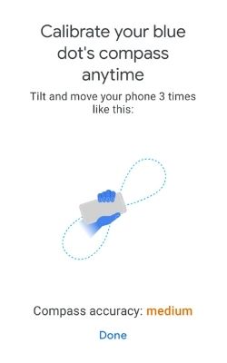
This is also a method more formally known as Compass calibration.
- Start with opening up Google Maps on any device Android or iPhone.
- Make sure you can see the blue dot location indicator on your map.
- Tap on the location icon to bring up more information.
- Look for calibrate the compass and click on it.
- Tilt and move your phone three times in figure eight like motion.
- Google Maps will let you know once it is successfully calibrated.
Improve accuracy of your location with Live View
Just when you thought there it was over, there’s still one other way you can improve the accuracy of your location.
Google has cleverly used a feature called Live View as a method of locating you with more accuracy.
The following are steps on how to get this going.
- On your smartphone open up the Google Maps app.
- Enter the location and search for it.
- Tap on the circular location icon at the bottom of the screen.
- Tap on Calibrate with live view.
- Follow the instructions and point your phone camera at the buildings and signs around you. Avoid the trees and people.
- Google will process the data from your camera and give you a more accurate position location.
If all else fails, restart your device.
Depending on what device you were using, you should go ahead and turn the device off and then turn it back on.
Alternatively, most smartphones and computer devices will have a restart button in which you could use.
The bottom line
Google Maps and its location data capabilities can be a vastly complicated issue. However, when you find that Google is unable to locate your position then there are several methods you can attempt to solve this issue.
Other interesting articles: